5. Method for evaluating the danger of rainfall induced slope failure using topographical data
- A method was developed for evaluating the danger of rainfall induced landslides or embankment collapse using 3-D topographical data.
- This evaluation can be applied to pinpoint vulnerable slopes according to precipitation levels.
Rain induced landslides are greatly influenced by runoff from slopes (including mountain streams) and movement of water infiltrating into the surface soil layer. Work was therefore carried out to develop a method for calculating water displacement on the slope surface and in the ground using 3D topographical data. The results of these calculations were used to develop a method for assessing the risk of debris flows or embankment failure.
The risk of debris flow is closely related to the risk of slope failure close to a mountain stream and the volume of the flow in that stream.
Consequently, an analytical model was constructed to determine the volume of flow of the stream using 3D topographical data (Fig.1). By adding to this the risk of slope failure close to the mountain stream based on the volume of rain runoff from the slope (Fig.2) , a method was built to evaluate the risk of a debris flow occurring.
The risk of failure of embankments adjacent to natural or cut out slopes (Fig.1) depends largely on the volume of rain running off from the slope onto the embankment. A mesh model of the adjoining slope was thus used to calculate the volume of water running from the slope onto the embankment, which in turn was used to construct a method for calculating risk of embankment failure (Fig.3).
By using the methods described above, it has become possible to identify the location of high disaster risk slopes, depending on precipitation. Data to support decisions in setting priorities about where to implement risk prevention measures can thus be generated using these methods.
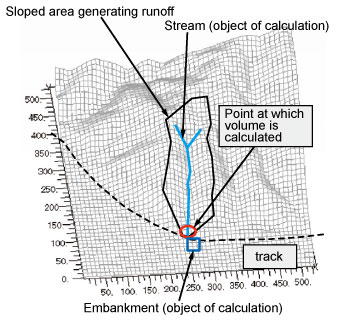
Fig.1 Mountain stream and embankment
forming object of the calculation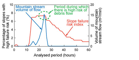
Fig.2 Example of failure risk of the slope adjoining
the stream and calculated stream volume of flow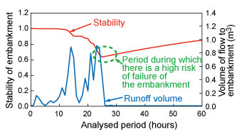
Fig.3 Example of calculated stability level and
runoff volume onto embankment
- Research and Development > Major Results of Research and Development in Fiscal 2012 > I Improvement of Safety
-

RTRI HOME - Copyright(c) 2013 Railway Technical Research Institute