|
The collapse of natural slopes, falling stones, landslides and avalanches of sand/stone along railway lines are related to conditions of geography, geology, underground water, vegetation and the environment. The RTRI has discussed a technique using satellite images and numerical altitude data for the survey and evaluation of these factors.
Aerial photos show that slope collapse occurs in undulated topography and under vegetative conditions featuring densely-distributed cutovers and post-felling areas of young Japanese redwood forests and secondary forests (Fig. 1). To evaluate the risk of natural disaster, the RTRI has also developed a technique to superimpose the results of geographical survey using numerical altitude data onto those of the analysis of vegetative conditions based on satellite images. Evaluation of a mountain consisting of hard sedimentary rock using this technique shows a close correlation between areas where the risk of disaster is high and those where slope collapse and other categories of natural disaster occur. This demonstrates the effectiveness of the technique in pinpointing areas prone to natural disaster (Fig. 2).
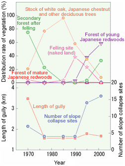
Fig. 1 Increases in the area subjected to slope collapse due to changes in the vegetative conditions of the catchment area | 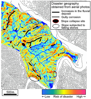
Fig. 2 A case of disaster risk evaluation based on numerical altitude data and analysis of satellite images |
HOME > Major Results of Research and Development in Fiscal 2004 > I Safety/Reliability

RTRI HOME
Copyright(c) 2005 Railway Technical Research Institute,Tokyo Japan, All rights reserved.
|