7.Identification method of potential landslide hazard areas and rock fall sources using Digital Elevation Model and Digital Surface Model
- Vegetal cover and terrain conditions common to landslide hazard spotsbecame clear.
- A method was developed to identify the potential landslide areas and outcrops of rock which could be the source of rock falls by using Digital Elevation Model and Digital Surface Model.
Several surveys were carried out in areas adjacent to railway to gain insight into the terrain characteristics common to potential landslide zones and rock fall sources, such as vegetal cover, topographical and geological conditions.
A digital elevation model and digital surface model were produced using Light Detection and Ranging (LiDAR). A method was subsequently developed, by converting the causes detected in the two models into digital format, for a wide-scope and objective identification of rock outcrops and potential landslide spot distribution.
Some areas that geology differs were surveyed and examine in order to identify the distribution of topographical features and vegetal cover and landslide. Results revealed that locations with the greatest tendency for landslide were those susceptible to water concentration, with a slope gradient of 30°and over and with low vegetal cover.
The vegetal cover and geometric form of slope collected through the digital elevation and surface layer models were then converted into digital format. Then, by combining three factors contributing to landslide as mentioned above, a method was developed create an identification of landslide hazard zones. (Figs. 1, 2 and 3).
The distribution of rock outcrops potentially giving rise to rock falls was mainly in zones with convex slopes with an inclination greater than 50°, a method was therefore also developed for identification of such rock outcrops by combining indicators for a convex slope with the slope inclination calculated from the digital elevation model (Figs.1 and 3).
This approach is effective as a rough surveying method which can be used for pinpointing areas worthy of more detailed investigations (field surveys and simulations etc.) as part of natural disaster prevention measures.
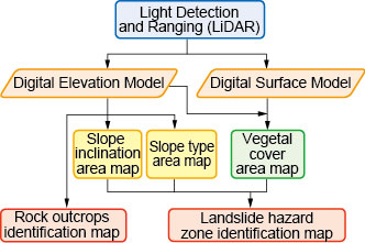
Fig.1 Flow chart for producing identification map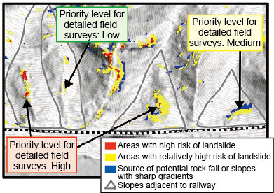
Fig.3 Result of identification of landslide hazard areas and rock fall sources
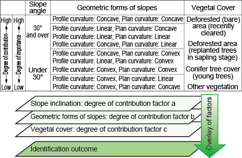
Fig.2 Method for combining factors contributing to landslide
- HOME > Major Results of Research and Development in Fiscal 2011 > I Improvement of Safety
-

RTRI HOME - Copyright(c) 2013 Railway Technical Research Institute