2. Compilation of subsurface ground and civil structure archive, and tool for automatic analytical modelling
- An archive was compiled of data about subsurface ground and civil structures associated with their latitude/longitude and kilometre points.
- A tool was then developed which, with limited data about ground/ structures, can automatically produce analytical models for simple earthquake disaster simulations for a whole line.
In order to evaluate the safety of the railway system during earthquakes, it is necessary to assess a line in its entirety. To this end, data about subsurface ground and civil structures in all track sections would have to be collected and a vast number of analytical models would have to be generated - something which to date has been too difficult to realize.
As such, an archive which simplifies management of data collected from ground and civil structures was developed. The archive associates information about the structures with their kilometer points and longitude/latitude, and data can be extracted for various uses. The database is designed to hold and manage a very broad range of content from simple to complex data, such as soil type and N value of the subsurface ground, or structure type and height, to results from soil tests and bar arrangements in structures. As mentioned above, simulation of an entire line requires modeling of a vast number of subsurface ground and civil structures. A method was therefore developed to do this with the limited data available. A multilayered single-dimension non-linear model of the subsurface layer can therefore be made using only soil quality and N value data, and an equivalent single degree of freedom model of a structure can be obtained with just the type of structure and its height. In addition, a tool was developed which automatically generates analytical models from data extracted from the archive.
Based on the method presented above, earthquake and disaster simulations of 100km track sections have become simpler, thus making it feasible to carry out a comprehensive safety evaluation of an entire line during an earthquake.
Furthermore, archive management (Fig.1) and displaying of analysis results (Fig.2) can be visualised via the Geographical Information System (GIS) interface. The next planned step in this research is to build an earthquake and disaster simulator, based on the method described above, for even more detailed analyses. This research was conducted with funding from the Ministry of Land, Infrastructure, Transport and Tourism.
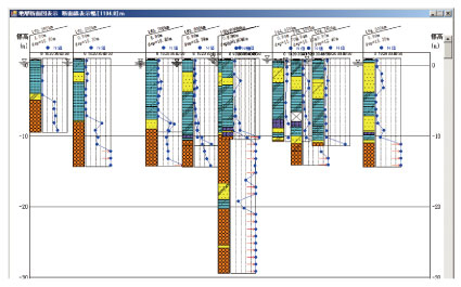
Fig.1 Geological profile of earth quality, through GIS interface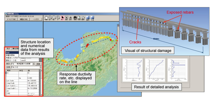
Fig.2 Earthquake and disaster simulation result of entire line, displayed on GIS interface
- Research and Development > Major Results of Research and Development in Fiscal 2012 > I Improvement of Safety
-

RTRI HOME - Copyright(c) 2013 Railway Technical Research Institute