1. Real-time hazard mapping system for localized heavy rainfall-induced disasters
Countermeasures to natural disasters caused by heavy localized rain, depend on being able to forecast these hazards, and being able to adapt responses over time. Being able to do this can help reduce damage and accelerate resumption of services following disruptions.
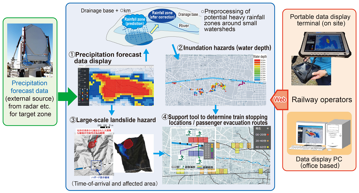
The system presented uses constantly updated precipitation forecasts analyzed in real time based on third party data and identifies inundation of small to medium sized watersheds and large-scale landslides at a certain distance from railway, and then depending on the outcome of these analyses shows suitable stopping locations for trains or passenger evacuation routes.
The developed system includes 4 sub-systems (Fig. 1):
① A system for converting random-points precipitation into graphs based on two-hour precipitation forecast data received approximately every ten minutes from external sources;
② A system which conducts sequential analysis of inundation hazards;
③ A system for displaying hazards when forecast precipitation reaches a given threshold in areas that have previously been identified as possible locations of large-scale landslides;
④ A system for displaying locations for trains to stop to avoid the hazard, and possible routes for passengers to take in the event of an evacuation.
This system can identify where natural disasters, inundations and large-scale landslides are likely to occur almost in real time, which can support operational decisions and determine evacuation routes and safe locations for passengers to flee to in the case of heavy localized rainfall, improving safety.
In addition, the system can prove useful for prior examination of equipment inspection periods and locations, to enable faster resumption of operations.
Other Contents
- 1. Real-time hazard mapping system for localized heavy rainfall-induced disasters
- 2. Earthing system testing device for lightning protection in power supply installations
- 3. Vertical damper to suppress decrease in wheel load on container wagon bogies
- 4. Seismic reinforcement methods for improving anti-catastrophe performance of railway viaducts
- 5. Support System for verifying evacuation safety in case of station fire
- 6. Early railway line tsunami inundation forecasting method
- 7. System for determining the stability of slopes during snowmelt season
- 8. Measures for reducing damage to overhead contact line system due to bridge oscillations caused by passing trains
- 9. VR-based training to prevent man-vehicle collision accidents
- 10. Method for evaluating train running safety during earthquakes considering non-linear behaviour of structures
- 11. Critical wind speed of overturning based on actual measured lateral vibration acceleration