6. Early railway line tsunami inundation forecasting method
In order to accurately estimate the water depth of inundations caused by a tsunami immediately after an earthquake, it would be effective to develop a method that uses tsunami data from the open sea transmitted from public institutions.
Consequently, tsunami data from the National Research Institute for Earth Science and Disaster Resilience and the results of a previously conducted tsunami simulation were used to develop an early tsunami inundation forecasting method.
In step 1 of this method (Fig. 1), using tsunami data observed at one station out at sea and a previously prepared tsunami propagation function obtained through numerical simulation of a tsunami, an estimation is made of the expected tsunami height at the coastline.
In step 2, using inundation maps for various earthquake scenarios collected in a database, the inland inundation area matching the estimated coastline tsunami height is extracted. This method therefore has the unique feature of being able to improve not only the timeliness of warnings using data from a single observation station, but can also increase the impact on stability of the warnings by building databases of tsunami propagation functions and inundation maps ahead of time.
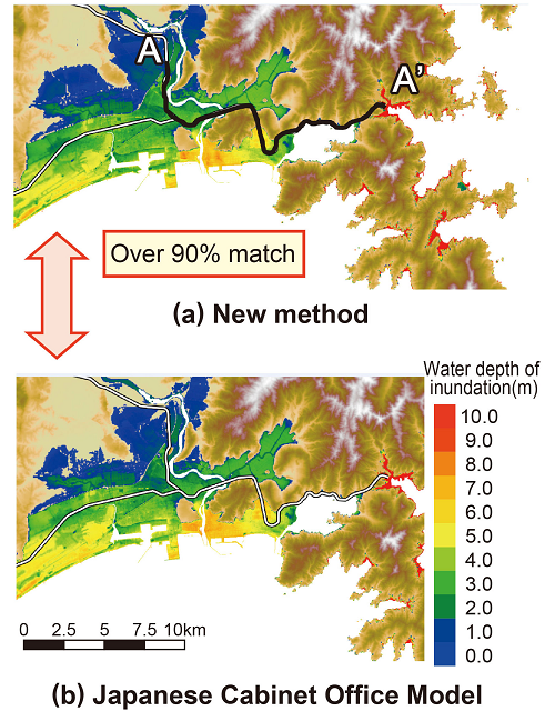
Applying this method to data from the 2011 off the Pacific coast of Tohoku Earthquake, and comparing the subsequent inundation areas with those from the model issued by the Japanese Cabinet Office as an accurate reference, it was confirmed that both areas matched by over 90% (Fig. 2).
By the same measure, it was also confirmed that the water depth of inundations caused by the tsunami could be estimated approximately one hour before reaching the railway tracks.
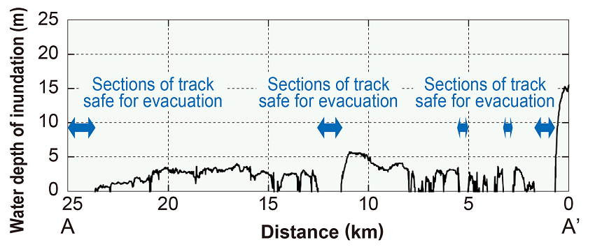
Applying this method immediately after receiving tsunami data observed in the open sea, and by displaying the water depth of inundations caused by the tsunami around the tracks, it would be possible to communicate to trains ahead of the flooding, which sections of track they could move to in order to remain safe for evacuation (Fig.3).

Other Contents
- 1. Real-time hazard mapping system for localized heavy rainfall-induced disasters
- 2. Earthing system testing device for lightning protection in power supply installations
- 3. Vertical damper to suppress decrease in wheel load on container wagon bogies
- 4. Seismic reinforcement methods for improving anti-catastrophe performance of railway viaducts
- 5. Support System for verifying evacuation safety in case of station fire
- 6. Early railway line tsunami inundation forecasting method
- 7. System for determining the stability of slopes during snowmelt season
- 8. Measures for reducing damage to overhead contact line system due to bridge oscillations caused by passing trains
- 9. VR-based training to prevent man-vehicle collision accidents
- 10. Method for evaluating train running safety during earthquakes considering non-linear behaviour of structures
- 11. Critical wind speed of overturning based on actual measured lateral vibration acceleration