7. System for determining the stability of slopes during snowmelt season
A method has been developed to determine the stability of slopes during snowmelt season using the amount of snowmelt as an index.
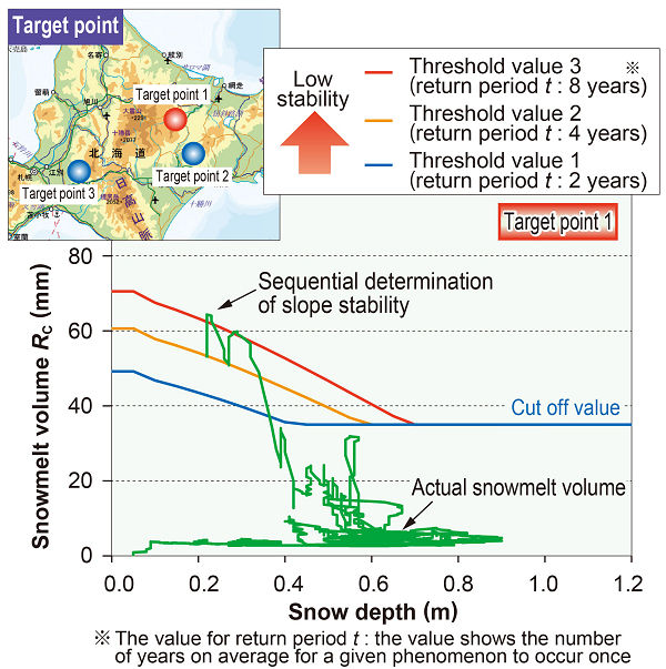
In the existing method, the maximum amount of snowmelt in the area is used as a threshold for determining that slope stability has declined.
However, in past geo-disasters, there have been cases where it was not possible to determine whether slope stability had declined.
Therefore, a method has been proposed to determine slope stability using two indicators: the snowmelt volume and snow depth.
The new method uses observation data from AMeDAS and public geographical data in the vicinity of the target point to estimate the amount of snowmelt and snow depth in order to determine slope stability.
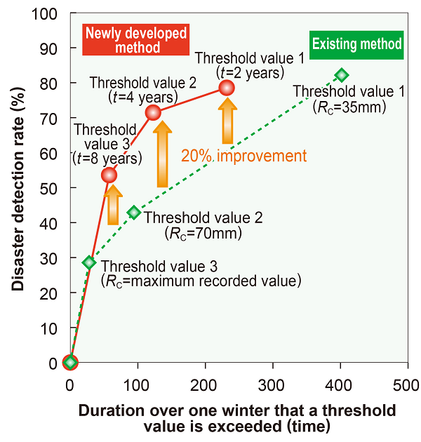
Using AMeDAS data, past snowmelt volumes for each snow depth are then calculated and then set as threshold values. By comparing the threshold values with actual snowmelt volumes and snow depth calculated on the basis of AMeDAS data updated on an hourly basis, it is possible to determine the slope stability (Fig. 1). Taking past geo-disasters as a reference, the ratios of successfully detected deteriorated slopes (disaster detection rate) using the existing and newly developed methods were compared.
The results of the comparison confirmed that even though results in both systems were the same in terms of the time in which the amount of snowmelt exceeded the threshold value, the newly developed method’s disaster detection rate was approximately 20% higher than the existing method (Fig. 2).
Given that the new method only uses publicly available data and information, it allows the stability of any slope to be examined, without the need to install a new network of observation equipment.
In addition, the system is designed so that if the system is used in an environment with internet access, the user can obtain a visual display of the slope stability result in any location, as shown in Fig. 1.
Other Contents
- 1. Real-time hazard mapping system for localized heavy rainfall-induced disasters
- 2. Earthing system testing device for lightning protection in power supply installations
- 3. Vertical damper to suppress decrease in wheel load on container wagon bogies
- 4. Seismic reinforcement methods for improving anti-catastrophe performance of railway viaducts
- 5. Support System for verifying evacuation safety in case of station fire
- 6. Early railway line tsunami inundation forecasting method
- 7. System for determining the stability of slopes during snowmelt season
- 8. Measures for reducing damage to overhead contact line system due to bridge oscillations caused by passing trains
- 9. VR-based training to prevent man-vehicle collision accidents
- 10. Method for evaluating train running safety during earthquakes considering non-linear behaviour of structures
- 11. Critical wind speed of overturning based on actual measured lateral vibration acceleration