
2. Real-Time Spatial Earthquake Motion Estimation Using Machine Learning
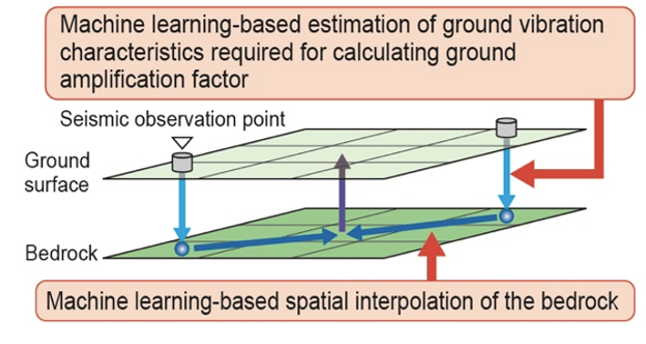
In the Damage Information System for Earthquake on Railway (DISER), earthquake motions of the ground surface observed at discrete measurement stations are first converted to bedrock earthquake motions by applying the ground amplification factors (light blue arrows, Fig. 1). The spatial distribution of bedrock earthquake motions is then estimated through spatial interpolation (blue arrows, Fig. 1). Finally, the estimated motions are transformed back into a surface ground distribution by reapplying the ground amplification factors (purple arrow, Fig. 1). However, the system has several limitations. In the spatial interpolation of bedrock motion, only the distance from observation points is considered. In addition, when geotechnical survey data are unavailable, amplification factors are estimated using a multiple regression model based on limited topographic information such as elevation.
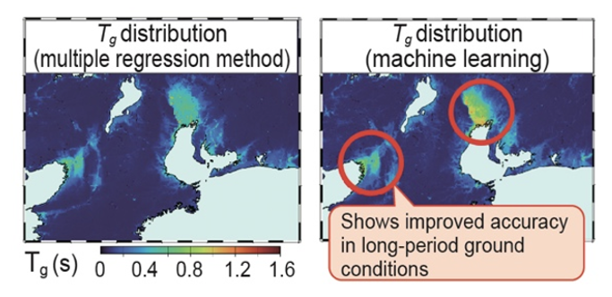
To improve the accuracy of spatial estimation of surface earthquake motions, we first incorporated a machine learning approach into the spatial interpolation of bedrock motion, taking into account factors such as hypocenter location, distribution of observation points, and subsurface geological conditions below the bedrock. We then incorporated a machine learning approach into the estimation of vibration characteristics of ground required for calculating ground amplification factors, taking into account topographic information such as distance to mountains, coastlines, and rivers, as well as terrain slope. For example, by estimating vibration characteristics of ground (natural period, Tg) using topographic information, the estimation accuracy is improved compared with that of a multiple regression model, particularly in plains where soft ground is widely distributed (Fig. 2).
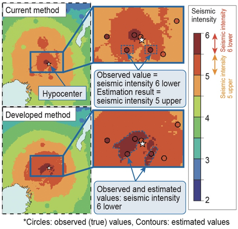
Results of a retrospective analysis of the 2018 Northern Osaka Earthquake (Fig. 3) demonstrate the improved estimation accuracy of the proposed method. While locations that actually experienced seismic intensity 6 lower are estimated as intensity 5 upper using the current method, the proposed method correctly estimates them as approximately intensity 6 lower. Furthermore, validation using 215 historical earthquakes confirmed that the proposed method improves the estimation accuracy of seismic earthquake motion indices, including seismic intensity, by approximately 10% on average nationwide and by approximately 30% in areas with soft ground, such as those indicated by the red circles in Fig. 2.
In the future, the proposed method will be implemented into DISER to enable more accurate and faster provision of spatial distributions of earthquake motion. This will support decision-making on the resumption of train operations immediately after an earthquake and contribute to shorter service recovery times.
Other Contents
- 1. Railway Earthquake Disaster Prevention Method Using Distributed Acoustic Sensing (DAS)
- 2. Real-Time Spatial Earthquake Motion Estimation Using Machine Learning
- 3. Enhancement of Seismic Train-Running Safety on Viaducts Using Low-Cost Displacement-Suppression Dampers
- 4. Elucidation of Air Spring Behavior Under Large Displacements and Abnormal Conditions
- 5. Multifunctional Experiment Facility and Prediction Method for Hot Gas Layer Characteristics in Tunnel Fires
- 6. Granular Flame Retarder for Railway Seats Using a Self-Extinguishing Resin for Reducing Fire Risk
- 1. Railway Earthquake Disaster Prevention Method Using Distributed Acoustic Sensing (DAS)
- 2. Real-Time Spatial Earthquake Motion Estimation Using Machine Learning
- 3. Enhancement of Seismic Train-Running Safety on Viaducts Using Low-Cost Displacement-Suppression Dampers
- 4. Elucidation of Air Spring Behavior Under Large Displacements and Abnormal Conditions
- 5. Multifunctional Experiment Facility and Prediction Method for Hot Gas Layer Characteristics in Tunnel Fires
- 6. Granular Flame Retarder for Railway Seats Using a Self-Extinguishing Resin for Reducing Fire Risk