6. Disaster Hazard Mapping Technology
Hazard mapping for natural disasters is useful for railway maintenance and disaster prevention planning. Having a system which could show various natural disaster factors in an integrated display would facilitate evaluation of many different types of disaster scenarios for disaster prevention planning, and make it easier to identify the sources and external forces involved. Such a system would also facilitate the design of effective countermeasures.
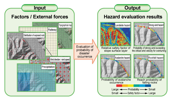
To this end, hazard mapping technology was developed to visualize the evaluated probability of disaster occurrences frequently occurring along railway lines, such as landslides, strong winds, avalanches, rockfalls etc., and the safety factor of slopes adjacent to railway lines, in map form using GIS (Geographic Information System).
The probability of disasters and safety factors are evaluated from extracted hazard factors, such as slope angles and distribution of exposed rock, and estimated external forces such as amount of precipitation, wind speed and direction (Figure 1).
A combination of methods already developed by RTRI and a new technique for extracting data about ground surface changes using airborne LiDAR (Light Detection and Ranging) and large area stability analyses of slopes during rain, was used to extract disaster factors, estimate external forces and evaluate the probability of disaster occurrences.
Using the newly developed hazard mapping technology, it will be possible to visualize spots vulnerable to natural disasters. This new system will be a useful tool for disaster prevention planning, since it will be possible to visualize on one single display not only the probability of occurrences of different types of natural disasters, but also their disaster factors and the magnitude of external forces.
Other Contents
- 1. Seismic ground motion simulator applicable to M9 earthquakes
- 2. Seismic Hazard simulator for railways
- 3. Early warning system employing ocean bottom seismometer data
- 4. Development of Railway Embankment Structures Resistant to severe Earthquakes and Prolonged Overflows caused by Tsunamis
- 5. Measures against buckling of ballasted track during earthquakes
- 6. Disaster Hazard Mapping Technology
- 7. Method for diagnosing condition of concrete roadbed in tunnels
- 8. Analytical method for evaluating carbody safety aimed at reducing passenger injury in case of level crossing collisions
- 9. Bogie to control decrement in wheel load
- 10. Mechanical pneumatic steering system with failsafe function
- 11. Gear oil for Shinkansen trains with improved startability in low temperature conditions
- 12. Process to select appropriate sounds to convey in-cab driver alerts
- 13. Training in communication techniques for train dispatchers in disrupted situations